Saltwater Fly Fishing Series
"Reading the Land and the Water for Salmon Fly Fishing Locations"
with Barry M. Thornton
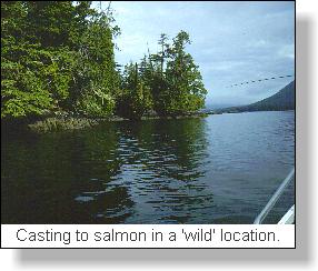
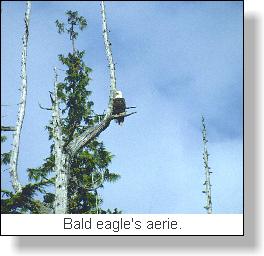 This is the Bald
Eagle's aerie! It is a 'wild' location, one which
makes you realize that we are each but a mote in our
world. But, it is not an uncommon west coast location
in British Columbia's 4000 plus miles of coastal fiords.
In fact, it is likely more representative of our salmon
sports fishing locations than any other in the Pacific
northwest. Bald Eagles patrol these areas on a regular
basis, and, at each major protruding point of land, the
white head of these majestic predators is quickly spotted
at the top of a weather formed but dominating evergreen
tree. This is the Eagle's solitary aerie, his lookout
where he perches while he watches the changing undulating
ocean waters for surface fish.
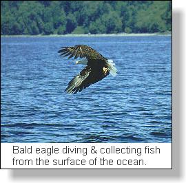 I have come to regard these
lonely but lofty predators as true friends in our
majestic Pacific coastal wilderness. Many I have found
will come when I call and take the bottomfish I offer.
They respond quickly to my whistle and grab the floating
bottomfish in a dramatic talon extended swoop, often very
close to the boat. I have come to regard these
lonely but lofty predators as true friends in our
majestic Pacific coastal wilderness. Many I have found
will come when I call and take the bottomfish I offer.
They respond quickly to my whistle and grab the floating
bottomfish in a dramatic talon extended swoop, often very
close to the boat.
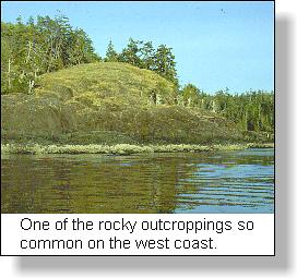
One representation of these 'wild' areas that I like
to fish are the rock bluffs off our numerous Gulf
Islands. These are characteristic areas typical of the
west coast environment. Sheer rock bluffs rise above the
waters of the Strait
of Georgia, often reaching heights well over 500
feet. Wind swept fir, pine, yew and arbutus evergreens
cling tenaciously to cracks in the rocks where scant
levels of soil have collected over the centuries.
Depending upon location, these timber monarchs of
protected valleys are, in these exposed bluffs, but
miniaturised stunted representatives of their race. They
are scant and wind blown, often with bleached bark on
open windward sides.
The tide line on the shore is made obvious by clinging
poppingwrack seaweeds attached to barnacle encrusted
rocks at the intertidal zone. In some small bays and rock
outcropping points, kelp sways back and forth with the
flooding or receding tide, for the ocean water are never
still.
This is what I like to experience as 'wilderness'
saltwater salmon fly fishing. Usually I am alone in these
locations, free to experiment with fly line depths and
weighted flies on underwater pinnacles, shoals,
drop-offs, rock shelves and submerged ledges. The salmon
are here but they are very specific to the various rock
structures that these 'wilderness' area provide.
For the salmon, it is for the concentrations of bait
that they search. But, once these have been found, the
salmon are certain to return should they have paused in
these waters, inhibiting the overwhelming migrating urge
that moves them through the vast waters of the Strait
towards their natal streams.
 Studying the cliffs along the
shoreline and watching the changes of depths on my depth
sounder it is obvious that these same surface cliffs
extended downward below me. As a Montana friend once
remarked about prairie coulees, these coastal underwater
cliffs are those 'upside down mountains'! Studying the cliffs along the
shoreline and watching the changes of depths on my depth
sounder it is obvious that these same surface cliffs
extended downward below me. As a Montana friend once
remarked about prairie coulees, these coastal underwater
cliffs are those 'upside down mountains'!
Studying a marine chart is one practical skill that
the saltwater fly fisher does every trip he takes on the
water. Once he becomes familiar with the topographical
lines that mark varying depths, exactly as surface
topographic map lines show mountain slopes, draws,
benches and river courses, the fly fisher can plot the
best location for intercepting feeding salmon.
I have found it almost uncanny how specific small
locations in the vast stretches of 'upside down
mountains' hold feeding salmon. Obviously there are
baitfish in the area but there is something else as well
which concentrates the salmon. One common factor which
has proven itself over the years has been the proximity
of a sheer deep drop-off at the salmon concentration.
Only in this one location do the fish concentrate. These
location I like to cal, salmon 'fishtrails'. Like 'game
trails,' they are very specific and it is only a matter
of time before salmon will move along them. When I have
been fortunate to locate one of these 'fishtrails' I will
anchor in a position that will allow me to cover the head
of the trail where the salmon first come up over the deep
edge onto the shoal, ledge or shallow. I use brightly
coloured buoys as markers to triangulate where the head
of this 'fishtrail' is located and, it is there that I
concentrate my casting.
 I have one location on the west
side of Texada Island that extends out into the Strait of
Georgia like a giant underwater shoe. The marine chart
tells me that this area will hold baitfish because it is
shallow like the top of the shoe and, that beside and at
the toes, are the 'fish trails' that will bring salmon to
this baitfish smorgasbord. It is one specific area that
holds spring bluebacks and summer coho and chinook. When
the salmon are on the feed, I have often anchored right
at the rocky shore outcrop and fly fished the shelves
where the baitfish have tried to hide. My success has
been varied simply because it is an exposed location and
only reachable during low wind times. But, it is a
location representative of the Bald Eagle's aerie and has
provided many exciting and moody moments. I have one location on the west
side of Texada Island that extends out into the Strait of
Georgia like a giant underwater shoe. The marine chart
tells me that this area will hold baitfish because it is
shallow like the top of the shoe and, that beside and at
the toes, are the 'fish trails' that will bring salmon to
this baitfish smorgasbord. It is one specific area that
holds spring bluebacks and summer coho and chinook. When
the salmon are on the feed, I have often anchored right
at the rocky shore outcrop and fly fished the shelves
where the baitfish have tried to hide. My success has
been varied simply because it is an exposed location and
only reachable during low wind times. But, it is a
location representative of the Bald Eagle's aerie and has
provided many exciting and moody moments.
Reading saltwater for salmon fly fishing involves many
factors including location, tides, baitfish and
concentrations of migrating salmon. Resolving the issue
of location is one factor that has received very little
discussion in the past except for a blanket 'secret'
fishing hole doctrine. The use of depth sounders has
opened a new era in salmon fishing. The fly fisher is
well advised to use this common tool in conjunction with
marine charts and land features to locate those salmon
'fishtrails' that provide such an outstanding sport.
�© Copyright Barry M. Thornton
Barry M. Thornton
|